

Best Practices For Adding Features
Today’s blog post explores the best practices for programmatically adding features to a layer.


ThinkGeo Basics: Styles
This week’s post is the second in a series of ‘ThinkGeo Basics’ that will dive into the fundamentals of building your own mapping solution. Today’s post will explore how Styles work in ThinkGeo.
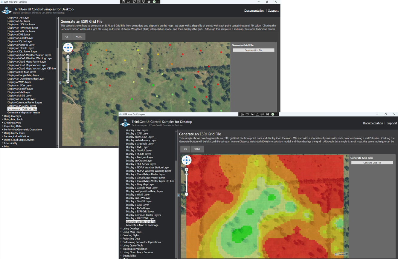
Generating Grid Files
Today’s blog post introduces a new ‘HowDoI’ sample that demonstrates how to generate and display an ESRI Grid File from point-based data.

ThinkGeo Basics: Feature Sources
This week’s post is the first in a series of ‘ThinkGeo Basics’ that will dive into the fundamentals of building your own mapping solution.


Applying a Directional Styling in a WPF Application
This ThinkGeo WPF ApplyDirectionPointStyleForLineStyle functionality for .NET Core will guide you through drawing lineStyles in the form of directional arrows on a map. The direction Point can be an image or a glyph, it not only rotates the icon across the angle of the road, but also provides a way to customize the rotation of the direction point.

Video Spotlight: Getting Started with ThinkGeo UI 12 & WPF
ThinkGeo UI WPF for .NET Core takes GIS application development for the Windows desktop to a whole new level, with a .NET Core-native control that packs the full power of Windows Presentation Foundation (WPF). With blazing fast rendering performance, powerful mapping features and support for the most popular data formats, ThinkGeo UI Desktop WPF for .NET Core makes GIS accessible to developers of any skill.

ThinkGeo’s 2019 U.S. Retail Closings Map & How We Built It
To create this map, we first gathered and aggregated U.S. store closings from major retailers like Sears and Family Dollar, who have issued these as simple lists of addresses. We then used a process called geocoding to convert those addresses into geographic coordinates; ThinkGeo offers both a cloud-based geocoding API and an embeddable geocoding component for .NET that can process thousands of addresses in seconds.

Map Suite Geocoder 2018 Data Refresh
Map Suite Geocoding is a native geocoding and reverse geocoding component for .NET that lets you convert a street address into a geographic location and vice-versa. It can also deliver additional details like county, FIPS codes, census tract and more. Plus, it ships with an optimized set of United States street data based on the latest TIGER® data from the U.S. Census Bureau.